File:"Bendybus", Belfast - geograph.org.uk - 716042.jpg
Tools
Actions
General
Print/export
In other projects
Appearance
From Wikimedia Commons, the free media repository
"Bendybus",_Belfast_-_geograph.org.uk_-_716042.jpg (640 × 374 pixels, file size: 92 KB, MIME type: image/jpeg)
File information
Structured data
Captions
Captions
"Bendybus", Belfast
Summary
[edit]Description"Bendybus", Belfast - geograph.org.uk - 716042.jpg |
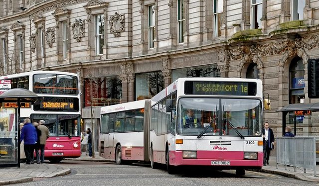
English: "Bendybus", Belfast There is a small fleet of bendy buses (articulated Mercedes) in the suburban fleet in Belfast. This one is about to depart Donegall Square West on service 1E to Roughfort via Glengormley (41 minutes). This used to be the longest run operated by Citybus but, with the amalgamation of some former Ulsterbus services under the Metro branding, it no longer holds that title. |
|||
Date | ||||
Source | From geograph.org.uk | |||
Author | Albert Bridge | |||
Other versions |
|
|||
Attribution (required by the license) InfoField | Albert Bridge / "Bendybus", Belfast / | |||
InfoField | Albert Bridge / "Bendybus", Belfast |
Camera location | 54° 35′ 50″ N, 5° 55′ 53″ W ![]() ![]() | View this and other nearby images on: OpenStreetMap | ![]() |
---|
Object location | 54° 35′ 49″ N, 5° 55′ 55″ W ![]() ![]() | View this and other nearby images on: OpenStreetMap | ![]() |
---|
Licensing
[edit]![]() |
This image was taken from the Geograph project collection. See this photograph's page on the Geograph website for the photographer's contact details. The copyright on this image is owned by Albert Bridge and is licensed for reuse under the Creative Commons Attribution-ShareAlike 2.0 license.
|


This file is licensed under the Creative Commons Attribution-Share Alike 2.0 Generic license.
Attribution: Albert Bridge
- You are free:
- to share – to copy, distribute and transmit the work
- to remix – to adapt the work
- Under the following conditions:
- attribution – You must give appropriate credit, provide a link to the license, and indicate if changes were made. You may do so in any reasonable manner, but not in any way that suggests the licensor endorses you or your use.
- share alike – If you remix, transform, or build upon the material, you must distribute your contributions under the same or compatible license as the original.
File history
Click on a date/time to view the file as it appeared at that time.
Date/Time | Thumbnail | Dimensions | User | Comment | |
---|---|---|---|---|---|
current | 00:33, 19 February 2011 | ![]() | 640 × 374 (92 KB) | GeographBot (talk | contribs) | == {{int:filedesc}} == {{Information |description={{en|1="Bendybus", Belfast There is a small fleet of bendy buses (articulated Mercedes) in the suburban fleet in Belfast. This one is about to depart Donegall Square West on service 1E to Roughfort vi |
You cannot overwrite this file.
File usage on Commons
The following page uses this file:
Structured data
depicts/a>"}},"text//plain":{"en":{"":"depicts"}}},"{/"value/":{/"entity-type/":/"item/",/"numeric-id/":5638,/"id/":/"Q5638/"},/"type/":/"wikibase-entityid/"}":{"text//html":{"en":{"P180":"bus/a>"}},"text//plain":{"en":{"P180":"bus"}}},"{/"value/":{/"entity-type/":/"item/",/"numeric-id/":10686,/"id/":/"Q10686/"},/"type/":/"wikibase-entityid/"}":{"text//html":{"en":{"P180":"Belfast/a>"}},"text//plain":{"en":{"P180":"Belfast"}}}}" class="wbmi-entityview-statementsGroup wbmi-entityview-statementsGroup-P180 oo-ui-layout oo-ui-panelLayout oo-ui-panelLayout-framed">
creator/a>"}},"text//plain":{"en":{"":"creator"}}},"{/"value/":{/"entity-type/":/"property/",/"numeric-id/":2093,/"id/":/"P2093/"},/"type/":/"wikibase-entityid/"}":{"text//html":{"en":{"":"author name string<\/a>"}},"text\/plain":{"en":{"":"author name string"}}},"{\"value\":\"Albert Bridge\",\"type\":\"string\"}":{"text\/html":{"en":{"P2093":"Albert Bridge"}},"text\/plain":{"en":{"P2093":"Albert Bridge"}}},"{\"value\":{\"entity-type\":\"property\",\"numeric-id\":2699,\"id\":\"P2699\"},\"type\":\"wikibase-entityid\"}":{"text\/html":{"en":{"":"<a target=\"_blank\" title=\"d:Special:EntityPage\/P2699\" href=https://commons.wikimedia.org/"https:////www.wikidata.org//wiki//Special:EntityPage//P2699/">URL/a>"}},"text//plain":{"en":{"":"URL"}}},"{/"value/":/"https:////////www.geograph.org.uk////profile////5835/",/"type/":/"string/"}":{"text//html":{"en":{"P2699":"https:////www.geograph.org.uk//profile//5835/a>"}},"text//plain":{"en":{"P2699":"https:////www.geograph.org.uk//profile//5835"}}},"{/"value/":{/"entity-type/":/"property/",/"numeric-id/":3831,/"id/":/"P3831/"},/"type/":/"wikibase-entityid/"}":{"text//html":{"en":{"":"object of statement has role<\/a>"}},"text\/plain":{"en":{"":"object of statement has role"}}},"{\"value\":{\"entity-type\":\"item\",\"numeric-id\":33231,\"id\":\"Q33231\"},\"type\":\"wikibase-entityid\"}":{"text\/html":{"en":{"P3831":"<a target=\"_blank\" title=\"d:Special:EntityPage\/Q33231\" href=https://commons.wikimedia.org/"https:////www.wikidata.org//wiki//Special:EntityPage//Q33231/">photographer/a>"}},"text//plain":{"en":{"P3831":"photographer"}}}}" class="wbmi-entityview-statementsGroup wbmi-entityview-statementsGroup-P170 oo-ui-layout oo-ui-panelLayout oo-ui-panelLayout-framed">
some value
copyright status<\/a>"}},"text\/plain":{"en":{"":"copyright status"}}},"{\"value\":{\"entity-type\":\"item\",\"numeric-id\":50423863,\"id\":\"Q50423863\"},\"type\":\"wikibase-entityid\"}":{"text\/html":{"en":{"P6216":"<a target=\"_blank\" title=\"d:Special:EntityPage\/Q50423863\" href=https://commons.wikimedia.org/"https:////www.wikidata.org//wiki//Special:EntityPage//Q50423863/">copyrighted/a>"}},"text//plain":{"en":{"P6216":"copyrighted"}}}}" class="wbmi-entityview-statementsGroup wbmi-entityview-statementsGroup-P6216 oo-ui-layout oo-ui-panelLayout oo-ui-panelLayout-framed">
copyright license<\/a>"}},"text\/plain":{"en":{"":"copyright license"}}},"{\"value\":{\"entity-type\":\"item\",\"numeric-id\":19068220,\"id\":\"Q19068220\"},\"type\":\"wikibase-entityid\"}":{"text\/html":{"en":{"P275":"<a target=\"_blank\" title=\"d:Special:EntityPage\/Q19068220\" href=https://commons.wikimedia.org/"https:////www.wikidata.org//wiki//Special:EntityPage//Q19068220/">Creative Commons Attribution-ShareAlike 2.0 Generic<\/a>"}},"text\/plain":{"en":{"P275":"Creative Commons Attribution-ShareAlike 2.0 Generic"}}},"{\"value\":{\"entity-type\":\"property\",\"numeric-id\":1476,\"id\":\"P1476\"},\"type\":\"wikibase-entityid\"}":{"text\/html":{"en":{"":"<a target=\"_blank\" title=\"d:Special:EntityPage\/P1476\" href=https://commons.wikimedia.org/"https:////www.wikidata.org//wiki//Special:EntityPage//P1476/">title/a>"}},"text//plain":{"en":{"":"title"}}},"{/"value/":{/"text/":/"///"Bendybus///", Belfast\",\"language\":\"en\"},\"type\":\"monolingualtext\"}":{"text\/html":{"en":{"P1476":"<span lang=\"en\" class=\"wb-monolingualtext-value\">\"Bendybus\", Belfast<\/span> <span class=\"wb-monolingualtext-language-name\" dir=\"auto\">(English)<\/span>"}},"text\/plain":{"en":{"P1476":"\"Bendybus\", Belfast"}}},"{\"value\":{\"entity-type\":\"property\",\"numeric-id\":2093,\"id\":\"P2093\"},\"type\":\"wikibase-entityid\"}":{"text\/html":{"en":{"":"<a target=\"_blank\" title=\"d:Special:EntityPage\/P2093\" href=https://commons.wikimedia.org/"https:////www.wikidata.org//wiki//Special:EntityPage//P2093/">author name string<\/a>"}},"text\/plain":{"en":{"":"author name string"}}},"{\"value\":\"Albert Bridge\",\"type\":\"string\"}":{"text\/html":{"en":{"P2093":"Albert Bridge"}},"text\/plain":{"en":{"P2093":"Albert Bridge"}}}}" class="wbmi-entityview-statementsGroup wbmi-entityview-statementsGroup-P275 oo-ui-layout oo-ui-panelLayout oo-ui-panelLayout-framed">
inception/a>"}},"text//plain":{"en":{"":"inception"}}},"{/"value/":{/"time/":/"+2008-03-06T00:00:00Z/",/"timezone/":0,/"before/":0,/"after/":0,/"precision/":11,/"calendarmodel/":/"http:////////www.wikidata.org////entity////Q1985727/"},/"type/":/"time/"}":{"text//html":{"en":{"P571":"6 March 2008"}},"text\/plain":{"en":{"P571":"6 March 2008"}}}}" class="wbmi-entityview-statementsGroup wbmi-entityview-statementsGroup-P571 oo-ui-layout oo-ui-panelLayout oo-ui-panelLayout-framed">
6 March 2008
source of file<\/a>"}},"text\/plain":{"en":{"":"source of file"}}},"{\"value\":{\"entity-type\":\"item\",\"numeric-id\":74228490,\"id\":\"Q74228490\"},\"type\":\"wikibase-entityid\"}":{"text\/html":{"en":{"P7482":"<a target=\"_blank\" title=\"d:Special:EntityPage\/Q74228490\" href=https://commons.wikimedia.org/"https:////www.wikidata.org//wiki//Special:EntityPage//Q74228490/">file available on the internet<\/a>"}},"text\/plain":{"en":{"P7482":"file available on the internet"}}},"{\"value\":{\"entity-type\":\"property\",\"numeric-id\":7384,\"id\":\"P7384\"},\"type\":\"wikibase-entityid\"}":{"text\/html":{"en":{"":"<a target=\"_blank\" title=\"d:Special:EntityPage\/P7384\" href=https://commons.wikimedia.org/"https:////www.wikidata.org//wiki//Special:EntityPage//P7384/">geograph.org.uk image ID<\/a>"}},"text\/plain":{"en":{"":"geograph.org.uk image ID"}}},"{\"value\":\"716042\",\"type\":\"string\"}":{"text\/html":{"en":{"P7384":"<a target=\"_blank\" class=\"wb-external-id external\" href=https://commons.wikimedia.org/"https:////www.geograph.org.uk//photo//716042/" rel=\"nofollow\">716042<\/a>"}},"text\/plain":{"en":{"P7384":"716042"}}},"{\"value\":{\"entity-type\":\"property\",\"numeric-id\":137,\"id\":\"P137\"},\"type\":\"wikibase-entityid\"}":{"text\/html":{"en":{"":"<a target=\"_blank\" title=\"d:Special:EntityPage\/P137\" href=https://commons.wikimedia.org/"https:////www.wikidata.org//wiki//Special:EntityPage//P137/">operator/a>"}},"text//plain":{"en":{"":"operator"}}},"{/"value/":{/"entity-type/":/"item/",/"numeric-id/":1503119,/"id/":/"Q1503119/"},/"type/":/"wikibase-entityid/"}":{"text//html":{"en":{"P137":"Geograph Britain and Ireland<\/a>"}},"text\/plain":{"en":{"P137":"Geograph Britain and Ireland"}}},"{\"value\":{\"entity-type\":\"property\",\"numeric-id\":973,\"id\":\"P973\"},\"type\":\"wikibase-entityid\"}":{"text\/html":{"en":{"":"<a target=\"_blank\" title=\"d:Special:EntityPage\/P973\" href=https://commons.wikimedia.org/"https:////www.wikidata.org//wiki//Special:EntityPage//P973/">described at URL<\/a>"}},"text\/plain":{"en":{"":"described at URL"}}},"{\"value\":\"https:\\\/\\\/www.geograph.org.uk\\\/photo\\\/716042\",\"type\":\"string\"}":{"text\/html":{"en":{"P973":"<a target=\"_blank\" rel=\"nofollow\" class=\"external free\" href=https://commons.wikimedia.org/"https:////www.geograph.org.uk//photo//716042/">https:////www.geograph.org.uk//photo//716042/a>"}},"text//plain":{"en":{"P973":"https:////www.geograph.org.uk//photo//716042"}}}}" class="wbmi-entityview-statementsGroup wbmi-entityview-statementsGroup-P7482 oo-ui-layout oo-ui-panelLayout oo-ui-panelLayout-framed">
coordinates of the point of view<\/a>"}},"text\/plain":{"en":{"":"coordinates of the point of view"}}},"{\"value\":{\"latitude\":54.5973,\"longitude\":-5.9314,\"altitude\":null,\"precision\":0.0001,\"globe\":\"http:\\\/\\\/www.wikidata.org\\\/entity\\\/Q2\"},\"type\":\"globecoordinate\"}":{"text\/html":{"en":{"P1259":"54\u00b035'50.3"N, 5\u00b055'53.0"W"}},"text\/plain":{"en":{"P1259":"54\u00b035'50.3\"N, 5\u00b055'53.0\"W"}}},"{\"value\":{\"entity-type\":\"property\",\"numeric-id\":7787,\"id\":\"P7787\"},\"type\":\"wikibase-entityid\"}":{"text\/html":{"en":{"":"<a target=\"_blank\" title=\"d:Special:EntityPage\/P7787\" href=https://commons.wikimedia.org/"https:////www.wikidata.org//wiki//Special:EntityPage//P7787/">heading/a>"}},"text//plain":{"en":{"":"heading"}}},"{/"value/":{/"amount/":/"+202/",/"unit/":/"http:////////www.wikidata.org////entity////Q28390/"},/"type/":/"quantity/"}":{"text//html":{"en":{"P7787":"202 <span class=\"wb-unit\">degree<\/span>"}},"text\/plain":{"en":{"P7787":"202 degree"}}}}" class="wbmi-entityview-statementsGroup wbmi-entityview-statementsGroup-P1259 oo-ui-layout oo-ui-panelLayout oo-ui-panelLayout-framed">
54°35'50.3"N, 5°55'53.0"W
coordinates of depicted place<\/a>"}},"text\/plain":{"en":{"":"coordinates of depicted place"}}},"{\"value\":{\"latitude\":54.59695,\"longitude\":-5.9319,\"altitude\":null,\"precision\":1.0e-5,\"globe\":\"http:\\\/\\\/www.wikidata.org\\\/entity\\\/Q2\"},\"type\":\"globecoordinate\"}":{"text\/html":{"en":{"P9149":"54\u00b035'49.02"N, 5\u00b055'54.84"W"}},"text\/plain":{"en":{"P9149":"54\u00b035'49.02\"N, 5\u00b055'54.84\"W"}}},"{\"value\":{\"entity-type\":\"property\",\"numeric-id\":7787,\"id\":\"P7787\"},\"type\":\"wikibase-entityid\"}":{"text\/html":{"en":{"":"<a target=\"_blank\" title=\"d:Special:EntityPage\/P7787\" href=https://commons.wikimedia.org/"https:////www.wikidata.org//wiki//Special:EntityPage//P7787/">heading/a>"}},"text//plain":{"en":{"":"heading"}}},"{/"value/":{/"amount/":/"+202/",/"unit/":/"http:////////www.wikidata.org////entity////Q28390/"},/"type/":/"quantity/"}":{"text//html":{"en":{"P7787":"202 <span class=\"wb-unit\">degree<\/span>"}},"text\/plain":{"en":{"P7787":"202 degree"}}}}" class="wbmi-entityview-statementsGroup wbmi-entityview-statementsGroup-P9149 oo-ui-layout oo-ui-panelLayout oo-ui-panelLayout-framed">
54°35'49.02"N, 5°55'54.84"W
media type<\/a>"}},"text\/plain":{"en":{"":"media type"}}},"{\"value\":\"image\\\/jpeg\",\"type\":\"string\"}":{"text\/html":{"en":{"P1163":"image\/jpeg"}},"text\/plain":{"en":{"P1163":"image\/jpeg"}}}}" class="wbmi-entityview-statementsGroup wbmi-entityview-statementsGroup-P1163 oo-ui-layout oo-ui-panelLayout oo-ui-panelLayout-framed">
image/jpeg
checksum/a>"}},"text//plain":{"en":{"":"checksum"}}},"{/"value/":/"007cf8ef31f5c0d2dbdc72a905f27d56df152768/",/"type/":/"string/"}":{"text//html":{"en":{"P4092":"007cf8ef31f5c0d2dbdc72a905f27d56df152768"}},"text//plain":{"en":{"P4092":"007cf8ef31f5c0d2dbdc72a905f27d56df152768"}}},"{/"value/":{/"entity-type/":/"property/",/"numeric-id/":459,/"id/":/"P459/"},/"type/":/"wikibase-entityid/"}":{"text//html":{"en":{"":"determination method or standard<\/a>"}},"text\/plain":{"en":{"":"determination method or standard"}}},"{\"value\":{\"entity-type\":\"item\",\"numeric-id\":13414952,\"id\":\"Q13414952\"},\"type\":\"wikibase-entityid\"}":{"text\/html":{"en":{"P459":"<a target=\"_blank\" title=\"d:Special:EntityPage\/Q13414952\" href=https://commons.wikimedia.org/"https:////www.wikidata.org//wiki//Special:EntityPage//Q13414952/">SHA-1/a>"}},"text//plain":{"en":{"P459":"SHA-1"}}}}" class="wbmi-entityview-statementsGroup wbmi-entityview-statementsGroup-P4092 oo-ui-layout oo-ui-panelLayout oo-ui-panelLayout-framed">
007cf8ef31f5c0d2dbdc72a905f27d56df152768
data size<\/a>"}},"text\/plain":{"en":{"":"data size"}}},"{\"value\":{\"amount\":\"+94115\",\"unit\":\"http:\\\/\\\/www.wikidata.org\\\/entity\\\/Q8799\"},\"type\":\"quantity\"}":{"text\/html":{"en":{"P3575":"94,115 <span class=\"wb-unit\">byte<\/span>"}},"text\/plain":{"en":{"P3575":"94,115 byte"}}}}" class="wbmi-entityview-statementsGroup wbmi-entityview-statementsGroup-P3575 oo-ui-layout oo-ui-panelLayout oo-ui-panelLayout-framed">
94,115 byte
height/a>"}},"text//plain":{"en":{"":"height"}}},"{/"value/":{/"amount/":/"+374/",/"unit/":/"http:////////www.wikidata.org////entity////Q355198/"},/"type/":/"quantity/"}":{"text//html":{"en":{"P2048":"374 <span class=\"wb-unit\">pixel<\/span>"}},"text\/plain":{"en":{"P2048":"374 pixel"}}}}" class="wbmi-entityview-statementsGroup wbmi-entityview-statementsGroup-P2048 oo-ui-layout oo-ui-panelLayout oo-ui-panelLayout-framed">
374 pixel
width/a>"}},"text//plain":{"en":{"":"width"}}},"{/"value/":{/"amount/":/"+640/",/"unit/":/"http:////////www.wikidata.org////entity////Q355198/"},/"type/":/"quantity/"}":{"text//html":{"en":{"P2049":"640 <span class=\"wb-unit\">pixel<\/span>"}},"text\/plain":{"en":{"P2049":"640 pixel"}}}}" class="wbmi-entityview-statementsGroup wbmi-entityview-statementsGroup-P2049 oo-ui-layout oo-ui-panelLayout oo-ui-panelLayout-framed">
640 pixel
geograph.org.uk image ID<\/a>"}},"text\/plain":{"en":{"":"geograph.org.uk image ID"}}},"{\"value\":\"716042\",\"type\":\"string\"}":{"text\/html":{"en":{"P7384":"<a target=\"_blank\" class=\"wb-external-id external\" href=https://commons.wikimedia.org/"https:////www.geograph.org.uk//photo//716042/" rel=\"nofollow\">716042<\/a>"}},"text\/plain":{"en":{"P7384":"716042"}}}}" class="wbmi-entityview-statementsGroup wbmi-entityview-statementsGroup-P7384 oo-ui-layout oo-ui-panelLayout oo-ui-panelLayout-framed">
instance of<\/a>"}},"text\/plain":{"en":{"":"instance of"}}},"{\"value\":{\"entity-type\":\"item\",\"numeric-id\":125191,\"id\":\"Q125191\"},\"type\":\"wikibase-entityid\"}":{"text\/html":{"en":{"P31":"<a target=\"_blank\" title=\"d:Special:EntityPage\/Q125191\" href=https://commons.wikimedia.org/"https:////www.wikidata.org//wiki//Special:EntityPage//Q125191/">photograph/a>"}},"text//plain":{"en":{"P31":"photograph"}}}}" class="wbmi-entityview-statementsGroup wbmi-entityview-statementsGroup-P31 oo-ui-layout oo-ui-panelLayout oo-ui-panelLayout-framed">
location of creation<\/a>"}},"text\/plain":{"en":{"":"location of creation"}}},"{\"value\":{\"entity-type\":\"item\",\"numeric-id\":10686,\"id\":\"Q10686\"},\"type\":\"wikibase-entityid\"}":{"text\/html":{"en":{"P1071":"<a target=\"_blank\" title=\"d:Special:EntityPage\/Q10686\" href=https://commons.wikimedia.org/"https:////www.wikidata.org//wiki//Special:EntityPage//Q10686/">Belfast/a>"}},"text//plain":{"en":{"P1071":"Belfast"}}}}" class="wbmi-entityview-statementsGroup wbmi-entityview-statementsGroup-P1071 oo-ui-layout oo-ui-panelLayout oo-ui-panelLayout-framed">
Categories:
- Donegall Square West
- Metro (Belfast) bus stops
- March 2008 in Belfast
- Buses in Belfast
- Bus stops in Belfast
- Alexander ALX400 on Volvo B7TL buses in the United Kingdom
- Mercedes-Benz O405GN buses in the United Kingdom
- Buses in the United Kingdom photographed in March 2008
- 2 buses in the United Kingdom
- Northern Irish registered buses in Northern Ireland